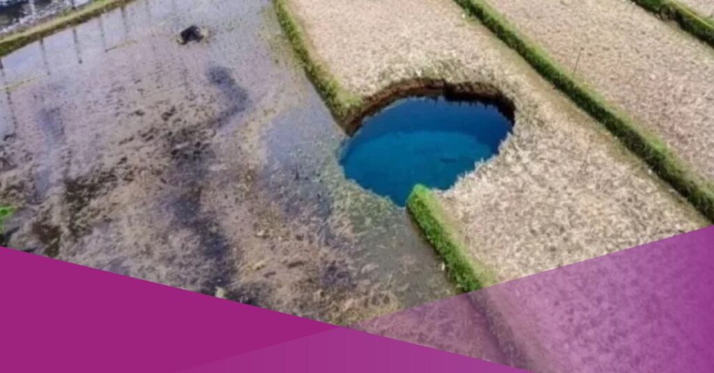
A sinkhole has appeared in Nagari Situjuah Batua, Limapuluh Kota Regency, West Sumatra, drawing attention from residents and authorities. The hole is estimated to be around 15 metres deep and formed in the middle of a rice field.
As reported by Kompas TV on Monday, January 5, 2026, the sinkhole emerged after residents heard a loud rumbling sound. The head of Jorong Tepi, Salim, said the noise prompted locals to investigate.
“There was a rumbling sound, or like a very large object falling into the water. When we looked for the source of the sound, it turned out to be a hole in the middle of a rice field,” Salim said.
He added that a landslide occurred shortly after the hole appeared, causing it to widen further.
“This morning there was no water, it was still very deep, estimated to be around 15 metres, but within a short time the hole grew larger,” he said.
No casualties were reported in the incident. However, the sinkhole has since filled with clear blue water and attracted visitors. Some residents have been seen taking photographs and bathing at the site.
BRIN Warns of Geological Risks in Limestone Areas
The National Research and Innovation Agency (BRIN) has warned that sinkholes are a geological phenomenon that requires caution, particularly in areas with limestone or chalk layers beneath the surface.
Adrin Tohari, Head of the Geological Disaster Research Center at BRIN, said regions with limestone formations are vulnerable to underground cavities that can lead to sinkholes.
“Therefore, if surface water flow suddenly disappears, we need to be aware of cavities in the limestone layer beneath the surface that could cause a sinkhole,” Adrin wrote, as quoted from BRIN’s official Instagram account on Monday, January 19, 2026.
Adrin explained that sinkholes do not form suddenly. Instead, they develop through a long-term natural process beneath the ground.
In a separate statement to national media in Jakarta on Friday, January 16, 2026, Adrin said sinkholes result from the gradual collapse of limestone layers below the surface.
“This process takes a very long time and is triggered by rainwater, which is acidic because it absorbs carbon dioxide (CO₂) from the air and the ground surface,” he said.
According to BRIN, several regions in Indonesia are known to have karst landscapes that are prone to sinkhole formation.
BRIN Outlines Five Key Facts About Sinkholes
BRIN has released five key points to help the public understand sinkholes and their potential risks.
First, a sinkhole is a depression or hole that appears on the ground surface due to the collapse of limestone or chalk layers beneath it. The collapse occurs after prolonged underground erosion rather than a sudden event.
Second, sinkholes form when rainwater absorbs gases from the air, becoming acidic. This water seeps into the ground and dissolves limestone or chalk, creating cracks and cavities that gradually expand.
Third, sinkholes commonly occur in areas with limestone formations. In Indonesia, such areas include karst regions like Gunung Kidul, Pacitan, and Maros.
Fourth, sinkholes are difficult to detect from the surface because the process occurs underground. BRIN noted that cavities can be identified through geophysical surveys, including gravity, georadar, and geoelectric methods. These surveys help map the depth and size of underground voids.
Fifth, BRIN cautioned against assuming that clear sinkhole water is safe. The water originates from rainwater and groundwater, but its quality must be tested.
“Chemical and microbiological tests are required to ensure water quality,” BRIN stated, including tests for pH levels, bacteria such as E. coli, and heavy metal content.
BRIN stressed that water can only be considered safe for consumption if it meets established health standards.