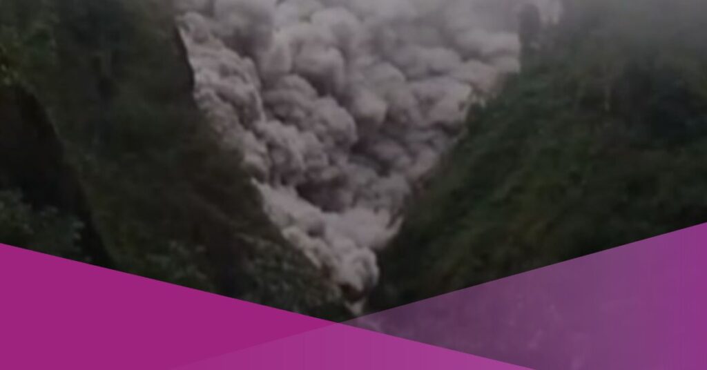
A viral video shows a hot cloud avalanche from Mount Semeru passing the Gladak Perak Bridge in Sumberwuluh Village, Candipuro District, Lumajang Regency, East Java.
According to the Semeru Volcano Observation Post (PPGA), the hot clouds had been moving from the crater since 2:30 PM Western Indonesian Time (WIB) and have now reached a distance of 14 kilometres. PPGA confirmed that the eruption remains ongoing, with dark conditions and heavy ashfall reported in several areas.
Mount Semeru erupted on Wednesday (19 November 2025), prompting the Geological Agency to raise its status from Level III (Standby) to Level IV (Alert). The escalation followed the release of a significant pyroclastic flow and increased seismic activity. The eruption produced a thick grey ash column drifting northwest to north.
DetikJatim reported that earlier in the day, the volcano discharged a pyroclastic flow extending 5.5 kilometres towards the Besuk Kobokan area. The seismograph at the Semeru Observation Post recorded a maximum amplitude of 40 mm and a duration of 16 minutes and 40 seconds.
Lihat postingan ini di Instagram
Sebuah kiriman dibagikan oleh Al Jazeera English (@aljazeeraenglish)
“Mount Semeru emitted a pyroclastic flow as far as 5.5 kilometres towards Besuk Kobokan,” said Isnugroho, Head of the Lumajang Regency Disaster Management Agency (BPBD).
Videos circulating online captured residents fleeing as ash clouds swept beneath the Gladak Perak Bridge. People could be heard urging others to seek higher ground while motorcyclists attempted to move away from the area.
Ali Murtopo, a resident of Sumber Sari Village, said the pyroclastic avalanche began at 14:13 WIB. “The eruption of pyroclastic flows from Mount Semeru caused residents of nearby villages to flee for safe locations. We ordered them to stop sand mining activities. Even residents living in government-built housing complexes affected by last year’s eruption panicked,” he told detikJatim.
In its official notice, the Geological Agency advised no activity within 8 kilometres of the summit. It also warned of potential pyroclastic flows, lava flows, and lahars along valleys and river channels linked to the peak. “This information indicates an increase in the activity level of Mount Semeru from Level III (Alert) to Level IV (Alert) at 5:00 PM WIB,” said M. Wafid, Head of the Geological Agency.
Climbing Route Closed; Emergency Declared; Evacuations Conducted
Following the escalation, the Bromo Tengger Semeru National Park (BB TNBTS) suspended all climbing activities, including the route to Ranu Kumbolo. Officials stated that the decision was based on recommendations from the Centre for Volcanology and Geological Disaster Mitigation (PVMBG).
“Considering the current conditions and recommendations from the Centre for Volcanology and Geological Disaster Mitigation, climbing on Mount Semeru, including the route to Ranu Kumbolo, is closed starting today until declared safe,” said TNBTS Head Rudijanta Tjahja Nugraha.
Authorities also highlighted a 20-kilometre sectoral zone to the south–southeast as an area that may potentially receive volcanic material.
The Lumajang Regency Government later issued Circular Letter Number 6 of 2025, declaring a seven-day emergency response period from 19 to 25 November 2025.
“I have declared an emergency response status for the natural disaster of the Mount Semeru eruption through Regent’s Decree Number 100.3.3.2/595/KEP/427.12/2025,” said Lumajang Regent Indah Amperawati. Sub-district and village heads were instructed to supervise evacuations and increase monitoring.
The National Disaster Management Agency (BNPB) confirmed that 178 climbers remain stranded around Ranu Kumbolo. BNPB will deploy a team to support evacuation efforts.
“Of course they will evacuate the climbers from Mount Semeru,” said BNPB Head Lieutenant General Suharyanto. He added that around 300 people have been evacuated to Oro-oro Ombo Village Hall, Penanggal Village Hall, and Supiturang 2nd Elementary School.
“Approximately 200 people are evacuated to the Oro-oro Ombo Village Hall, the Penanggal Village Hall is in the data collection process, and approximately 100 people are evacuated to the 2nd Elementary School of Supiturang,” he said.