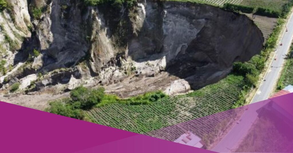
A giant sinkhole in Central Aceh Regency, Aceh, continues to expand, damaging nearby infrastructure and raising safety concerns for surrounding communities. The sinkhole is located in Pondok Balik Village, Ketol District, and has shown ongoing widening along its edges due to continuous landslides.
According to the Aceh Energy and Mineral Resources (ESDM) Agency, the total affected area reached 30,000 square metres, or approximately three hectares, based on monitoring conducted in 2026.
This marks a significant increase from 20,199 square metres recorded in 2021.
The Head of the Geology and Groundwater Division at the Aceh ESDM Agency, Ikhlas, stated that the gradual expansion has occurred over several years.
He attributed the growth to a combination of ground movement, high rainfall intensity, and extreme weather events affecting the region.
“The increase in area occurs gradually each year due to the effects of extreme weather, ground movement, and high rainfall intensity in the region,” Ikhlas said.
Volcanic Soil Composition and Seismic Activity
Geological analysis shows that the soil material at the sinkhole site originates from the Geureudong Formation. This formation consists of volcanic deposits produced by pyroclastic flows from Mount Geureudong, which erupted millions of years ago.
Mount Geureudong, located in neighbouring Bener Meriah Regency, is classified as an inactive Type B volcano and is significantly older than Mount Burni Telong.
According to the agency, the volcanic material in the area is loose and has high water absorption capacity, making it vulnerable to instability when saturated.
The expansion of the sinkhole has also been linked to recent seismic and weather events. The Gayo Earthquake, which was centred in Ketol District, and the impact of Cyclone Senyar in late November 2025 contributed to slope instability around the site.
Ikhlas explained that the location lies within the Sumatran Fault zone, an area known for frequent seismic activity. “The soil around the sinkhole is highly susceptible to erosion,” he said, noting that earthquakes and prolonged rainfall accelerate ground movement in the region.
Infrastructure Damage and Mitigation Measures
The widening sinkhole has already affected public infrastructure. Sections of the Takengon–Buter road have been damaged and partially swallowed by landslides. Agricultural land surrounding the site has also been impacted, resulting in the loss of horticultural crops, including chillies and onions.
In addition, landslides to the southeast of the sinkhole recently threatened high-voltage electricity transmission towers operated by state-owned utility PLN. The company relocated the towers as a precautionary measure to prevent further damage.
In response, the Aceh ESDM Agency has recommended immediate mitigation efforts. These include both structural and non-structural measures to reduce further erosion and landslide risks.
Cliff reinforcement and adjustments to surface drainage systems are considered necessary to prevent rainwater from flowing directly onto unstable slopes. Vegetation management has also been identified as a key component of mitigation.
“Planting trees on the slopes of landslides will help strengthen the soil, considering that in several locations where trees are present, landslides do not develop,” Ikhlas said, as quoted by Kompas.com.
Authorities continue to monitor the situation while coordinating with relevant agencies to manage risks in the affected area.