
Jakarta, Indonesia’s capital, has a population of 10 million people yet is one of the world’s fastest-sinking cities. Experts predict that if this continues, certain megacity areas may be completely flooded by 2050.
Jakarta has 13 rivers running through it, the Java Sea lapping against it, and it is situated on marshy soil. Therefore, it shouldn’t come as a surprise that flooding is a common occurrence in Jakarta and that it is reportedly becoming worse. However, this enormous metropolis of Jakarta is physically sinking into the ground, not merely experiencing odd floods.
The government constructed the coastal wall in 2002 to ensure that locals would have some time and peace of mind as the city’s land continued to sink and the water level continued to rise. However, the wall was no match for one of the worst floods in Jakarta’s modern history five years later, in 2007. The floods around the city claimed 80 lives and resulted in hundreds of millions of dollars in damage because a storm off the Java Sea and heavy rainfall fueled them.
Many Jakartans now have to constantly worry about another tragedy like the one that occurred in 2007, and certain places, which are less safe than Muara Baru, also experience recurring flooding. Proving that the tale of Jakarta, the sinking city is not a laughing matter and requires some serious action.
Learn more about the sinking city Jakarta here
In North Jakarta, the effects are quickly seen. North Jakarta has fallen 2.5 meters in the past ten years and is still sinking, with certain areas losing up to 25 centimetres annually. This number is more than double the average global rate for coastal urban areas.
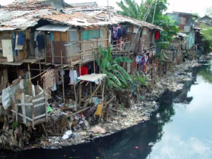
Almost half of Jakarta is now sinking in water as a result of Jakarta’s typical annual sinking rate of 1 to 15 cm. An entire office building is abandoned in the Muara Baru neighbourhood. The first-floor veranda is the only remaining operable component of what originally housed a fishing operation.
Flooding has been one of the main issues in Jakarta for hundreds of years. Thirteen rivers go through the city’s delta, which it stands on, from mountains to the south, where Jakarta Bay is located. A protective barrier against storm tides formerly surrounded the delta in the form of dense mangroves. The mangrove forests mainly were cleared for development a long time ago.
In 1619, when the Dutch began colonizing Indonesia, they remodelled the city to make it resemble a typical Dutch town, complete with contemporary structures and canals. Although the canals were intended to manage to flood and regulate flow, some researchers contend that they made the underlying issue worse. Unless it is regularly replaced with fresh sediment from.
Interested about this topic? Check out our other articles: